Landscape structure and open-space system
Cells of Regeneration
A landscape structure to protect and reactivate an open-space system.
Role Group member, contributing across all parts of the project
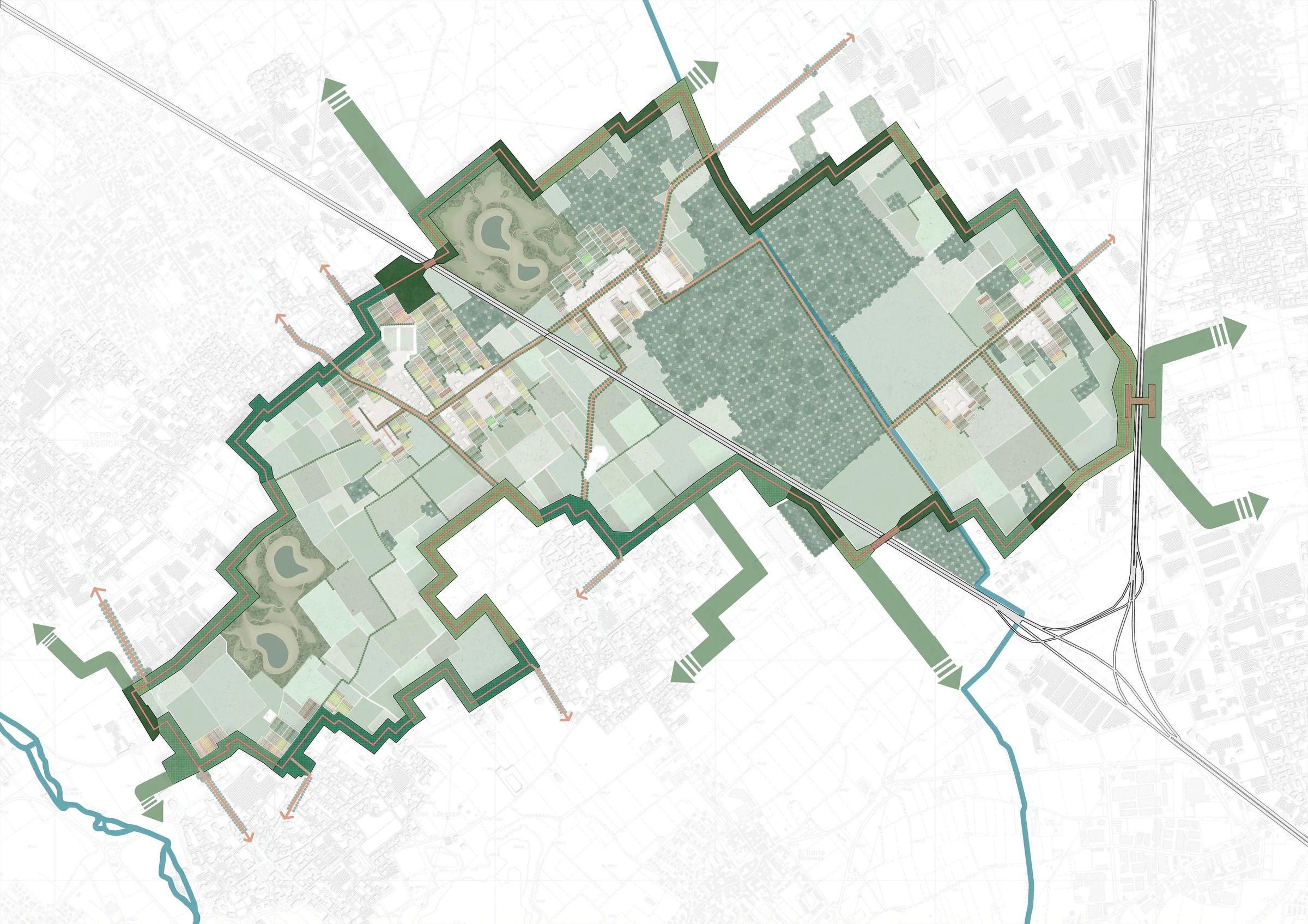
A landscape structure to protect and re-activate
The study area is located between Milan and Varese provinces in the Lombardy region, north of Italy. The transect stretches from the Olona River and its associated parks to the Bossente torrent and the Lura torrent.
After its industrial era, the territory's natural elements are slowly being re-invested in. Among a patchwork of urban and industrial clusters, a transversal clearing made of semi-natural components brings legibility in this otherwise undifferentiated landscape. Large surfaces of agricultural lands remain as the territory foundation. A centuries-old woodland stands out, while some quarries dig in and punctuate the land. These qualities and potentials call for a protective gesture.
Added · Adjusted · Erased · In 50 years
Objective 1
Added
- It is proposed to quickly "frame" (protect) those green spaces by creating a landscape infrastructure made of a linear mass of trees.
- In doing so, it opens opportunities for what is inside the frame, setting the conditions for a regeneration.
Objective 2
Adjusted
- Inside the frame is proposed a productive scenario.
- The agriculture is at a local scale, diverse and experimental, the quarries are providing water and the forests ensures a healthy ecological system.
Objective 3
Erased
- Industry clusters interrupting the clearing are re-localized outside, joining an existing cluster, while the agricultural practices turn towards a smaller scale.
Objective 4
In 50 years
- In 50 years, the protective frame provides an active, fluid experience through a new, productive landscape.
- It has become a landmark by its imposing scale, a destination for its diverse possibilities, and a local park by its familiarity, all at once.
The study area
Typical Landscape Sequence
The sequence is made of homogeneous urban areas, vast industrial clusters, two barriers (a highway and a railway), extensive open agricultural fields, a centuries-old woodland, and quarries filled with water and vegetation.
Analysis
Legend: Urban settlement · Industrial area · Agricultural land · Borromeo wood · Wooded area · Quarry.
Inferences
The clearing standing out of the actual landscape offers the opportunity to create a new system of green spaces at the fringe of the urban fabric and the industrial areas.
Master Plan
Legend: Urban settlement · Industrial zone · Threshold · Frame pathway · Quarry · Forest · Interior connections.
In 50 years
In 50 years, the protective frame provides an active, fluid experience through a new, productive landscape. It has become a landmark by its imposing scale, a destination for its diverse possibilities, and a local park by its familiarity, all at once.
Green System Evolution
Legend: Frame — Urban fringes · Industrial fringes · Agricultural fringes · Forest fringes. Inside — Existing Forest · Quarry Park · Pine park · Restored Cascina nodes · Sustainabe local farming · Fields. Also — Future extension · Threshold entry · Green pathway · Ecological bridge.
Detail Plan
A closer look at part of the master plan, where the frame, a quarry and the farmland meet.
The frame is a planted band with a pathway (the red line) that runs beside the railway.
The quarry becomes a landscape of two lakes, planting and looping paths.
Small farm plots gather around the existing settlement.
The System
Urban Fringe
The framework with a trail running through the center, surrounded by public plazas and community farming spaces inside the grid orchards for residents.
Agricultural Fringes
The trail continiues through a more distantly spaced tree grid with active public areas and high canopy coverage for uninterrupted views of the agricultural landscape.
Industrial Fringes
The trail passes through a very dence yet orderly tree grid, providing a buffer from the industrial fringe on one side and agriculture on the other with public spaces.
Bosco Fringes
The trail is lead through organically planted trees and shrubs which acts as the continoution of the surrounding Bosco which pocket spaces with in.
Project credits
- Project team
- Saba Seighali, Émilie Bielen, Abhinand Krishnakumar Menon, and Betül Güner
- Guidance
- Prof. Antonio Longo, Prof. Andrea Oldani, and Prof. Mara Gabbrielli